Loading...
Sierra Wireless
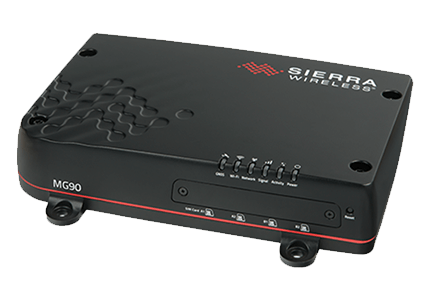
The AirLink® MG90 is a high performance LTE-Advanced Pro vehicle networking platform, purpose built to provide secure, always-on connectivity for mission critical applications in public safety, transit and field services.
With multi-network connectivity, the MG90 offers dual LTE-Advanced Pro radios, Gigabit Wi-Fi WAN and Gigabit Ethernet, with extensions to Land Mobile Radio (LMR) and satellite systems. The MG90 is also FirstNet ReadyTM with support for 700MHz Band 14, and support for priority and pre-emption for first responders.
The MG90 dynamically selects the best available network, based on user-customized scoring systems, using its intelligent policy defined link management, and is able to effortlessly switch between WAN connections to provide uninterrupted communications and prevent downtime, performance issues or dead zones. Together with the AirLink® Connection Manager (ACM), the MG90 consolidates the security for all connected technologies in the vehicle area network (VAN), vastly simplifying deployment and enabling the enterprise to retain management control over network access and connected mobile assets.
The MG90 seamlessly integrates with the AirLink® Mobility Manager (AMM)—a powerful, end-to-end network management solution—to enable simplified, remote and real-time insight and control of connected mobile assets and mission critical applications, and supports vehicle tracking, telemetry and asset management applications. Purpose built for the vehicle with its ruggedized form factor, the MG90 delivers best-inclass reliability and ensures continual operation in harsh mobile environments.

Built for first responders and in-field personnel, the AirLink MG90 offers up to 600 Mbps downlink and 150 Mbps uplink speeds over LTE Advanced Pro, 1.3 Gbps over dual radio, dual concurrent 3x3 MIMO 802.11ac Wi-Fi, and 5-port Gigabit Ethernet. The AirLink MG90 can host up to 128 clients at any one time, and concurrently connect multiple mission critical applications in and around the vehicle including laptops, MVRs and tablets, in addition to providing live video streaming, and rapid secure access to remote databases.
The AirLink MG90 supports up to 26 LTE frequency bands, enabling superior coverage on LTE networks worldwide including dedicated regional Public Safety bands such as FirstNet Band 14. The MG90 has five product variants: An LTEAdvanced Pro variant for North America that is FirstNet Ready with support for Band 14, a Global LTE-Advanced Pro variant with support for Band 20 and Band 28; LTEAdvanced variant for North America & EMEA and one for APAC; and one for the US with support for EV-DO fallback. With dual-SIM functionality for automatic failover between SIMs, the MG90 offers superior connectivity and cost optimization when roaming.
Purpose built for vehicle power environments, the AirLink MG90 does not require any external power conditioning, is optimized to survive extreme transient surges, and maintains continuous power through cold cranking as low as 5V.
The MG90 was developed with industrial grade components to accommodate extreme temperatures, such as a customized die cast aluminum housing to manage thermodynamics. It is sealed to meet IP64 for resistance to dust and water ingress, and has been tested to meet and exceed the MIL-STD-810G specifications for shock, vibration, temperature and humidity.
Offering built-in vehicle-ready I/O, Bluetooth and Vehicle Telemetry interface (requires external scanner kit), the MG90 enables remote monitoring of auxiliary devices, such as light bars, sirens and gun racks, and can collect OBD-II or J1939 vehicle telemetry data for engine diagnostic and performance data to monitor vehicle health.
Utilizing next generation GNSS location technology that supports 48 satellites from 4 different satellite constellations, the MG90 provides fast, reliable and precise vehicle location information, even in the most challenging environments. The MG90 contains an Inertial Navigation System that allows it to track without satellites, using dead reckoning algorithms integrated with the GNSS. The Inertial Navigation System continues to provide positioning information when the GNSS is unable to acquire satellites, enabling tracking through urban canyons, tunnels and underground parking.
Discover How Your Team Can Communicate Instantly, Without Boundaries, and with added Intelligence